Advances in smart cameras, sensors, data transfer, and artificial intelligence are prompting major cities to explore integrated technological solutions for traffic congestion. Two notable examples of this trend are pilot projects initiated by Wellington City Council in New Zealand and the New York City Department of Transportation.
Traffic congestion has long been a complex and pervasive issue in large cities. It leads to significant time wasted, reduced quality of life, and economic losses. Additionally, it contributes to environmental degradation through increased pollution and noise. Effectively managing traffic and enhancing road safety requires comprehensive data, which traditional methods like radar, pneumatic road tubes, and manual counting cannot adequately provide. These methods are often expensive and yield limited, narrow-focused data.
Advanced technologies are transforming urban transportation. By integrating smart cameras, sensors, data analytics, and artificial intelligence, cities can revolutionize traffic management. These tools promise to not only alleviate congestion but also optimize transportation systems, benefiting individuals and economies alike. Real-time data and AI-driven insights enable proactive decision-making and rapid responses to changing traffic conditions.
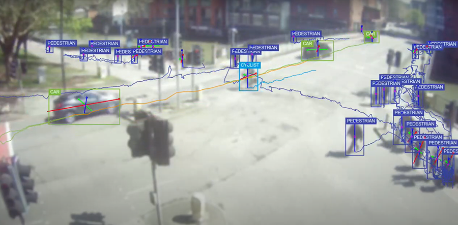
The innovative tools presented to urban planning authorities today integrate multiple modern technologies, addressing current challenges while driving significant advancements in the transport and communications sector. These tools positively impact various human and economic activities by offering unprecedented flexibility in managing traffic flow. They enable proactive decision-making and targeted interventions to respond immediately to changes in traffic conditions or emergencies. These promising technologies include embedded sensors equipped with high-resolution cameras, which provide real-time data analyzed by artificial intelligence to facilitate prompt and necessary decisions.
Wellington, for its part, is gearing up to embark on its own journey with these technologies by launching an advanced central traffic monitoring network that continuously collects, updates, and analyzes data from the roads directly, contributing to evidence-based traffic decision-making in a cost-effective manner. This network will replace the currently used automatic and manual counters, which have contributed to outlining long-term analyses but have fallen short of providing a deep and comprehensive picture of the traffic landscape due to their limitations in geographic coverage and capabilities.
The pilot system employs embedded sensors in small, smart cameras mounted on light poles, serving as real-time counters for all road users. It categorizes them into groups such as pedestrians, bicycles (including electric and motorized), motorcycles, buses, trucks, and other vehicles. These cameras capture still images and video clips, monitoring the path and speed of each road user within their field of view. Using a sequence of consecutive cameras, the system can track each user’s movement and route, their stop time at intersections, and the points where they make turns. To protect privacy, the system deletes individual data immediately after obtaining the necessary statistical data for analysis. This data is then transmitted directly to the traffic authorities at Wellington City Council. The project is estimated to cost around one million New Zealand dollars (590,000 US dollars) over five years.
The primary objective of this data is to help the City Council form an accurate picture of how roads and dedicated paths are used by each category of users at different times and how they move around the city. This will enable the Council to monitor the impact of changes made to the road network in real-time. Additionally, this data and its analysis will aid the Council in enhancing public safety, making informed decisions, and preparing for major events that impact the retail sector and the economy. Furthermore, this data will significantly contribute to future road design and urban planning.
In New York, the Department of Transportation has launched a similar innovative program to enhance safety and monitor how residents and vehicles use the city’s roads. This initiative aims to improve traffic management and reduce the city’s notorious congestion. The pilot project has installed smart cameras with sensor systems at 12 locations around the city to collect traffic data and generate instant reports. These reports will help evaluate the effectiveness of current safety programs and existing road designs. They will also assist officials in prioritizing locations most in need of safety measures and identifying areas for modifications to alleviate congestion. By providing information on residents’ travel patterns, such as their use of bus stops, loading docks, popular destinations, and heavily used bike paths, officials can improve services. As with the Wellington monitoring system, images that could identify residents are destroyed to maintain privacy standards.
With the success of this network, outdated and costly traffic monitoring methods will be replaced. These traditional methods, which rely primarily on field staff for manual vehicle counting and categorization or on fixed video cameras, have limitations in their results, timing, and geographic coverage. The new network will monitor and measure traffic elements similarly to Wellington’s system. However, what sets it apart is that New York City intends to make its network open-source, encouraging collaboration and innovation with external parties.
Both cities share a common approach in their innovative use of advanced sensor technologies to address traffic congestion challenges. Their experiences and lessons learned will undoubtedly provide valuable insights into these challenges and support similar applications in other cities. However, it is crucial to recognize the challenges these initiatives face, including data integration across different city council departments, ensuring privacy, and potential issues arising from third-party technology provider contracts.
References:
- https://wellington.govt.nz/parking-roads-and-transport/transport/traffic-counting-sensors
- https://wellington.govt.nz/news-and-events/news-and-information/our-wellington/2023/09/traffic-counting-sensors
- https://www.nyc.gov/html/dot/html/pr2023/dot-new-technology-improve-safety.shtml
- https://www.curbed.com/2023/04/nyc-dot-street-sensors-viva.html