San Francisco authorities are testing, Advanced technological solutions such as sensors that monitor movement at intersections and send data to controllers that adjust traffic light lights, In order to increase the efficiency of the system as a whole, and improve traffic.
An important part of the identity of smart cities is the modern transportation systems that use technology to manage traffic to improve safety and productivity. In light of the exacerbation of congestion challenges, high risk rates and the scarcity of the budgets of the transport authorities.
95% of train connections in San Francisco are delayed due to waiting at intersections. Sensors can, only on some intersections, Vehicle monitoring, While the surveillance cameras, which number more than 7,000 cameras, Only two-dimensional, limited-resolution images. It is estimated that road accidents in San Francisco annually kill about 30 people and cause serious injuries to 200 others. This prompted the authorities to launch the new city’s vision to improve safety and reach zero rates of road accidents.
The Municipal Transport Authority implements, Funded by the U.S. Department of Transportation, A pilot project to improve the traffic experience and give precedence to emergency vehicles and transport vehicles. The project is based on several innovations, As LiDAR for determining the range by light, intelligent multimedia traffic light systems, and dedicated short-range communications, Programming traffic light priorities, and the preference of emergency vehicles. These technologies detect objects at intersections and adjust signal timing accordingly. Including pedestrians and cyclists.
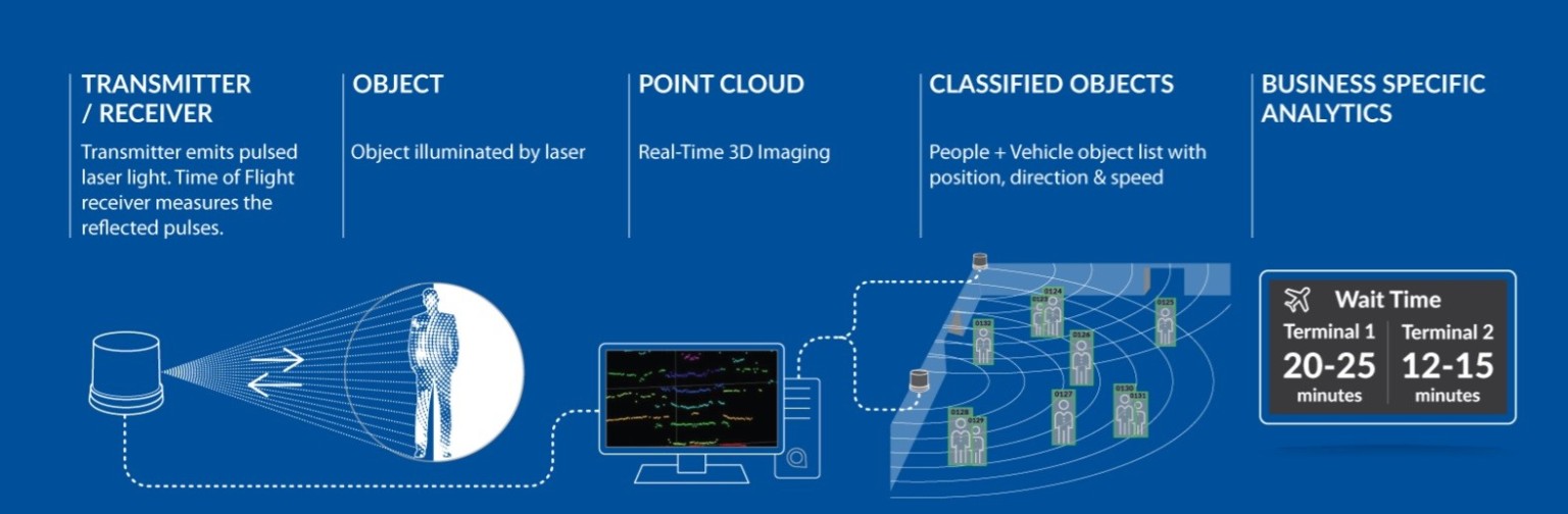
The main player in the project is lidar technology, which works around the clock and in various conditions and does not threaten the privacy of road users, It can track an unknown object through different sensor points, Like a car crossing several intersections or a person walking through different neighborhoods, The moving object has an identifier that stays with it throughout its journey in the area under observation.
First thing The transmitter emits pulsed laser light, It is a low-energy and safe rays for the eye, The receiver then tracks the reflected pulses. The principle of operation is to calculate how long the laser takes back and forth between the device and the target. After the target becomes a defined object, The resulting aggregated data is used to create a live three-dimensional cloud image. The latter carries information on the position, direction, velocity and classification of the object, It was determined whether he was walking or in a wheelchair, riding a bicycle or pushing a cart. These factors will help estimate the waiting time at traffic lights.
The project started with two proof-of-concept processes, The first turned to analysis and involved the installation of lidar devices at five intersections. If the devices were able to identify the data with 96% accuracy and without revealing the identity of the user, The second phase focuses on doubling the number and adding data to the signal control network, This is to activate the “intelligence” of intelligent transport systems. The databases include built-in controllers that in turn include automatic triggers. Currently, Work is underway to enable the exchange of information between these units and agencies on the ground.
The complex process was not without its challenges, When the body crosses multiple intersections, Tracking requires sequential sensors and multiple servers for “edge computing “ purposes[LZ1] ، It is a computing framework that approximates enterprise applications to data sources, which in this case are sensors. However, the vision of each device is limited to its area. This means that moving the object to another region creates another identifier for it, therefore, Loss of its trace. So, The team used a technique called “automated ID delivery.” To transfer the data of the person or vehicle from one device to another, the requirement of having a field of view, The team seeks to treat the entire corridor as a network rather than as individual nodes. Using high-frequency algorithms.
In the second trial, which began in July and August of the year 2021, Engineers and experts participated in the evaluation by attending in person or following surveillance cameras. Preliminary data indicated that the upgrade of traffic light timers, to correspond to a particular type of vehicle or one direction, may cause adverse effects for other road users, Such as pedestrians and vehicles not affiliated with the Railway Administration. The monitoring showed that the percentage of stopping other vehicles or pedestrians did not exceed 1%. Except for occasional parking on side streets, Her movement was not affected at all. But some important side streets, such as Mariposa, have seen an increase in average waiting times. The share of vehicles rose from 46 to 87 seconds in front of the red light, Pedestrians waited 22 to 26 seconds.
To avoid these effects, The team will work more on timer software, They proceeded to do so, relying on detailed information gathered by sophisticated devices, They made adjustments to take into account the timing, direction of movement, pedestrian traffic intensity and types of vehicles, And it responds to all this directly.
In the language of numbers, The pilot project achieved an increase in average travel speed of 21%. And raise the chances of the train reaching the intersections in conjunction with the green light from 62.1% to 85.8%. The delay did not exceed 10 seconds in 60% of transit flights. 20% saw no delays.
In addition to responding directly to the traffic situation, reducing emissions and facilitating the movement of transit and emergency vehicles, The Municipal Transport Authority will build on these findings to scale up the technology and use it in other vital facilities such as airports and gain a deeper understanding of the functioning of the transport system and the means to improve overall traffic and achieve sustainability.
References:
https://www.sfmta.com/blog/green-light-muni-customers
https://www.ibm.com/ae-ar/cloud/what-is-edge-computing
[LZ1]https://www.ibm.com/ae-ar/cloud/what-is-edge-computing