The world is beginning to realize the importance of data and cities are gathering data more than ever before. We can only seize this opportunity and harness this huge amount of information to devise plans and better manage and design municipalities. The best example of successful initiatives in this field is the Digital Twin, a powerful tool for data visualization, simulation, and collaboration, resulting in virtual copies of small and large physical objects, including buildings, cities, regions, and systems. Digital Twin is a crucial agent of change in technology, smart technology, and manufacturing.
Digital Twin is a safe way for industries, companies, individuals, and other government hubs to view all datasets, which are accurate, up-to-date, and easy to use. On another note, this tool is an open platform that can visualize 3D and 4D data over time, such as buildings, strata plans, terrain, property boundaries, and utilities, including power, water, and sewer pipes. Digital Twin acts as a bridge between the physical and digital worlds using sensors and IoT to collect real-time data on physical items. This data is then processed and used to understand, analyze, amend, and improve a given item. Infrastructure developers can use Digital Twin tools to identify the location of underground utilities before construction begins or see the potential impact of planned future infrastructure. Moreover, by gathering high-value transportation, infrastructure, property, planning, and environmental datasets directly from owners, the government and relevant sectors can ensure that they are all harnessing the same reliable data and are using them to effectively respond to different built and natural environments.
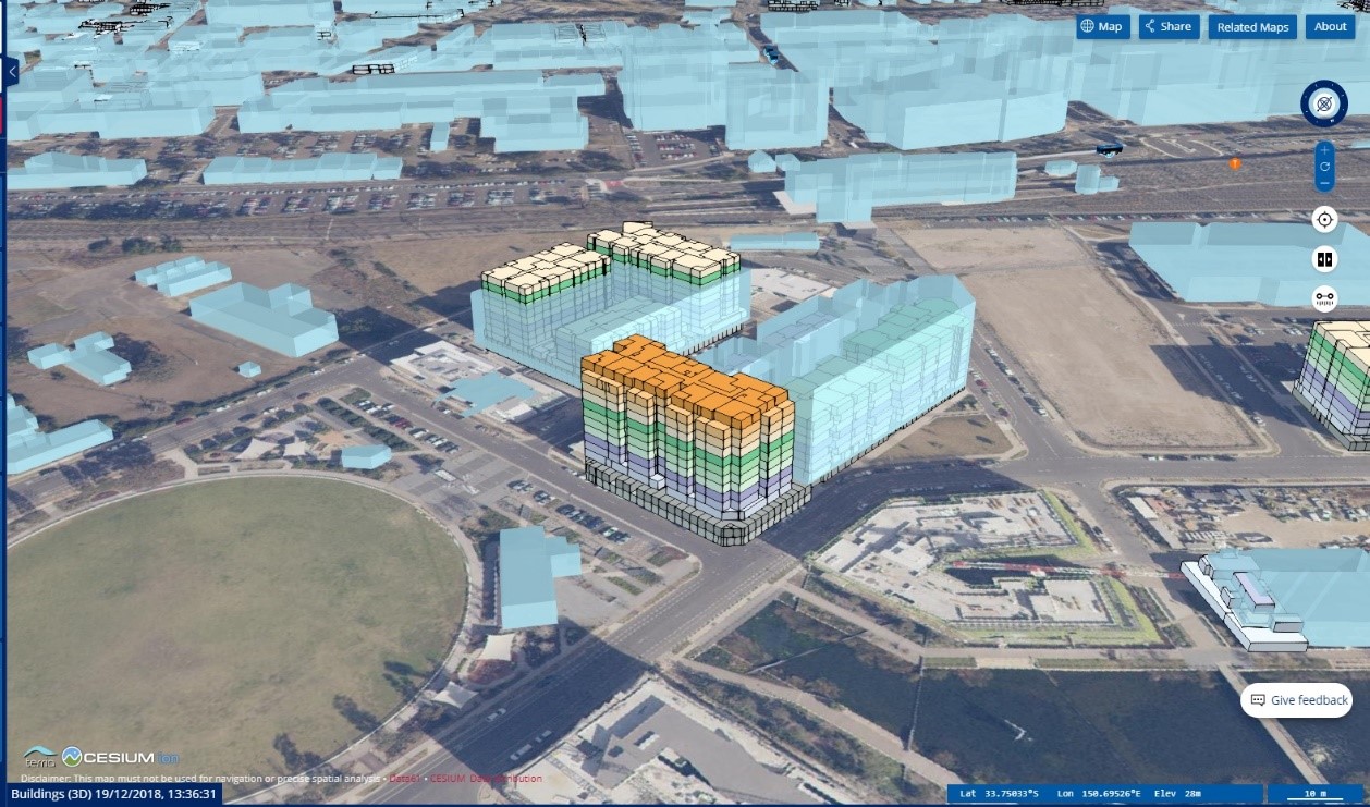
The NSW Government in Australia has launched the Spatial Digital Twin aimed at transforming and improving urban planning and infrastructure across Western Sydney. Implemented in partnership with CSIRO’s Data61, the NSW Spatial Digital Twin is expected to provide 3D and 4D digital spatial data and models of the built and natural environments. This interactive tool includes 22 million trees with height and canopy characteristics, almost 20,000 km of 3D roads and 7,000 3D strata plans, and 546,206 buildings.
The platform is committed to enabling integrated city planning processes by incorporating data sets from across the NSW government, such as infrastructure and live transport data (under and above the ground), and building information models and property boundaries (like strata boundaries).
The NSW Digital Twin was built on Data61’s TerriaJS platform, an open-source technology that also powers the National Map and the National Drought Map. The Digital Twin also incorporates the open-source catalog technology MAGDA that ensures its built-in security features to obtain certain types of data only. Customers can interact with dual virtual digital copies. For example, they can use the tool to add or remove layers to visualize the infrastructure in the past, present, and future in Western Sydney. Moreover, the digital data-sharing feature offered by the tool can be used to analyze suburbs, cities, and countries to develop plans to recover from and prevent natural disasters and climate change.
The new Digital Twin leverages Esri’s ArcGIS platform, which supports leading Digital Twin platforms in all smart cities of the world, including Singapore, Dubai, and Los Angeles.
The first phase of the digital product focuses on the minimum viable to create a high-resolution 4D model based on 3D aerial images and LIDAR, which is integrated with the state’s digital scanning system (register and location of plots of lands). Data related to transportation, utilities, planning, natural resource management, environmental management, and emergency management are gradually added. The platform also includes digital engineering assets, building information models, live API feeds for public transport, air quality, and energy production.
Although this platform primarily focuses on supporting infrastructure planning and implementation, the industry and community are benefiting at the national, provincial, and local levels. We cannot disregard the benefits of this platform as it covers all sectors, including infrastructure planning and implementation, service delivery and planning, environmental management, and natural resource management, in addition to emergency management and counter-terrorism. The platform will grow and become better through more engagement with local, government, national, and industry actors.
The Data Twin platform can be used for predictive analytics. Another example of Data Twin applications in NSW is the partnership between Transport NSW and Data61, which led to the development of an artificial intelligence (AI) engine to predict traffic congestion across Sydney. This engine complements existing solutions by integrating machine learning with traffic simulations to predict the developments of the transportation network in the short term. The engine’s role is to ingest transport datasets for the training of special-purpose predictive models, forming a closed loop with simulation models to continuously train the AI engine with new situations and responses and simultaneously calibrate the simulation model. The scientific fundamentals of the AI engine have been thoroughly tested using historical and real-time transportation datasets, such as smart card, GPS, and traffic signal data.
This achievement will implement the next-generation congestion management system for the NSW Transport Management Centre. The system works to enhance the capability to predict two hours into the future and take the appropriate measures within five minutes, which will likely lead to major enhancements in the efficient management of traffic flows.
The Digital Twin tools are a powerful force driving innovation and performance. The Digital Twin technology can help governments improve the experience of community members by better understanding their needs and making improvements to existing products, processes, and services.
Resources:
https://data61.csiro.au/en/Our-Research/Our-Work/Future-Cities/NSW-Digital-Twin/NSW-Digital-Twin
https://www.csiro.au/en/News/News-releases/2020/New-digital-twin-for-NSW
https://www.spatial.nsw.gov.au/what_we_do/projects/digital_twin
https://www.zdnet.com/article/nsw-governments-spatial-digital-twin-to-help-with-future-city-mapping/