Many local UK governments are seeking to integrate technology tools into their planning processes, using them to understand urban environments, draw interactive maps and 3D visualizations, and engage people in decision-making processes.
City planners need to design spaces for their children that fit their lifestyles, as cities must replicate their residents. Accordingly, it has become natural that today’s digital societies need cities built on this basis, and this design process can no longer be done in isolation from technology.
Previously, buildings in the United Kingdom had numerous problems related to natural phenomena, weather conditions and the surrounding environment, and urban projects often lacked scientific grounds in selecting sites, while many urban cities suffered from collapses of heritage buildings. All these challenges and others are due to the lack of sufficient information. When dealing with buildings of any type, their planners, designers and builders must have a full understanding of all the details, and all that falls above or below them.
Therefore, in 2018, the UK government decided to establish the Geospatial Commission, comprising a number of independent and non-governmental experts. They will be responsible for setting the UK’s geospatial strategy and coordinating its activities among the public sector.
It can be argued that, within these development endeavours, recognizing the role of modern technologies and increasing reliance on them has been the cornerstone. The introduction to these technologies is the Geographic Information System (GIS), a spatial system that creates, manages, analyses, and maps all types of data. GIS connects data to a map, integrating location data (where things are) with all types of descriptive information.
This system in the UK, as in many other countries, is used in various fields and sectors, such as engineering, transport, logistics, insurance, business and telecommunications. To increase these uses, the government recently collaborated with the private sector to organize a competition to find local planning authorities with innovative ideas for how best to use geospatial technology to help modernize the planning process. Of the 50 entries, local councils in Nottingham City, Dacorum Borough Council, and South Ayrshire won.
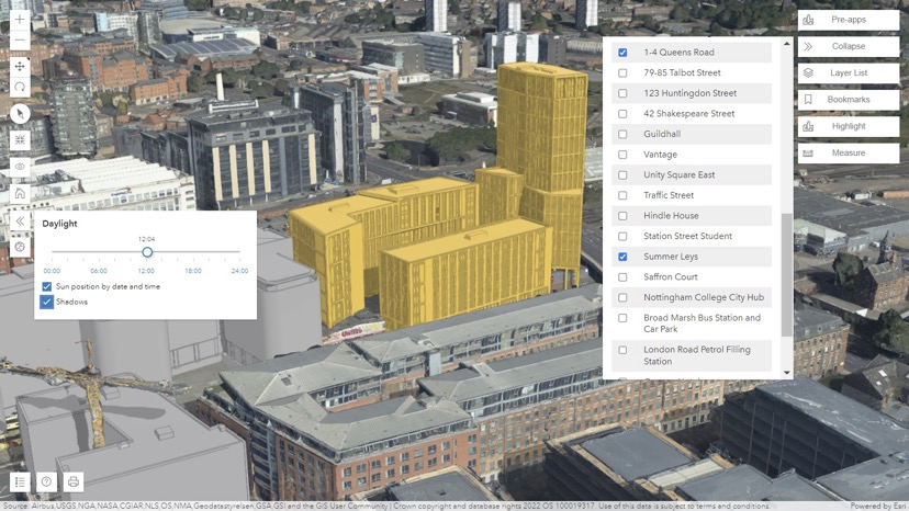
Nottingham City Council has developed a prototype 3D visualisation tool for site assessments in planning. The tool brings together all the relevant data into one 3D environment taking in the proposed planning scheme, conservation areas, site allocations, flood risk and tree cover. This has allowed planning teams to conduct 3D assessments of various constraints on a site, at the same time as a visual impact assessment, which speeds up decision-making.
Dacorum Borough Council’s pilot project has converted existing text and spreadsheet information into a digital mapping environment, improving how infrastructure and developer contributions secured through planning obligations are managed and communicated. It shows the value of using digital maps to visualise and monitor contributions spatially.
South Ayrshire Council’s project examined how a consultation platform using interactive engagement methods can help improve community and stakeholder engagement in local development plans (LDP), to reach better planning outcomes. It has created a platform designed to keep the public and other parties engaged and informed.
Other cities have also had their own experiences with this system, for example, Westminster has used the site analysis feature to determine the optimal routes that waste trucks should take to save time, effort and taxpayers’ money.
It is worth mentioning that the government is also conducting restoration of some semi-archaeological homes and streets, which date back to the early twentieth century. While the authorities are keen to protect their Victorian legacy, at the same time they want to make these structures suitable for the twenty-first century and able to meet its challenges and needs.
These pilot projects by the winning cities shed light on common challenges faced by different local authorities, and provided solutions that could be feasible. The idea of 3D graphics means building a better understanding and making more informed decisions for city planners. On the other hand, the idea of maps demonstrated the importance of a spatial understanding of investments by providing a visual and interactive explanation of how people’s money has been transformed into infrastructure, increasing trust between them and the authorities, enhancing transparency and reducing the margin of lax and corruption. The consultation platform project presented a typical example of the benefit of participation among all parties in setting development plans to reach the best results.
These projects have also demonstrated the ability of technology to improve planning processes, save cost and time, and help city planners build a deeper understanding of demographic data and patterns, which increases the efficiency of planning, quality management and the effectiveness of decision-making processes.
The UK government looks forward to using these technologies to maximise economic, social and environmental opportunities and to placing itself at the forefront of geospatial science at a global level.
References:
https://www.esri.com/en-us/what-is-gis/overview
https://assets.publishing.service.gov.uk/government/uploads/system/uploads/attachment_data/file/958420/MHCLG-Planning-Consultation.pdf
https://www.bimplus.co.uk/councils-demonstrate-role-of-gis-in-digital-planning-with-esri-uk/
https://www.geospatialworld.net/prime/technology-and-innovation/uk-local-authority-projects-use-gis-for-planning/
https://www.ukauthority.com/articles/nottingham-city-council-develops-3d-visualisation-prototype-for-planning-process/
https://assets.publishing.service.gov.uk/government/uploads/system/uploads/attachment_data/file/894755/Geospatial_Strategy.pdf
https://www.civilserviceworld.com/professions/article/how-the-geospatial-commission-is-putting-the-uk-on-the-map